Showing posts with label traveling. Show all posts

Tuesday, July 19, 2011

Milan's Duomo

Duomo


Duomo


Duomo


Duomo

Milan's magnificent Duomo is one of the largest cathedrals in the world. Construction was commissioned by bishop Antonio da Saluzzo in 1385. Although it was consecrated in 1418, the Duomo was not finished until the 19th century, when Napoleon had the façade completed.

The roof of the Duomo is decorated with more than 2200 statues. Most famous is the 4 m high gilded statue of Madonna which dates back to 1774. It's possible to access the roof by stairs or elevator and enjoy a panoramic view of the city.

The inside of Milan's Cathedral is rather dark. There are five large naves divided by 52 pillars that support the cross vaulted ceiling. The stained glass windows of the choir are said to be the largest in the world.

Thursday, June 30, 2011

Taj Mahal, Agra, India

taj mahal
Taj Mahal is regarded as one of the eight wonders of the world, and some Western historians have noted that its architectural beauty has never been surpassed. The Taj is the most beautiful monument built by the Mughals, the Muslim rulers of India. Taj Mahal is built entirely of white marble. Its stunning architectural beauty is beyond adequate description, particularly at dawn and sunset. The Taj seems to glow in the light of the full moon. On a foggy morning, the visitors experience the Taj as if suspended when viewed from across the Jamuna river.
Taj Mahal was built by a Muslim, Emperor Shah Jahan (died 1666 C.E.) in the memory of his dear wife and queen Mumtaz Mahal at Agra, India. It is an "elegy in marble" or some say an expression of a "dream." Taj Mahal (meaning Crown Palace) is a Mausoleum that houses the grave of queen Mumtaz Mahal at the lower chamber. The grave of Shah Jahan was added to it later. The queen’s real name was Arjumand Banu. In the tradition of the Mughals, important ladies of the royal family were given another name at their marriage or at some other significant event in their lives, and that new name was commonly used by the public. Shah Jahan's real name was Shahab-ud-din, and he was known as Prince Khurram before ascending to the throne in 1628.
Taj Mahal was constructed over a period of twenty-two years, employing twenty thousand workers. It was completed in 1648 C.E. at a cost of 32 Million Rupees. The construction documents show that its master architect was Ustad ‘Isa, the renowned Islamic architect of his time. The documents contain names of those employed and the inventory of construction materials and their origin. Expert craftsmen from Delhi, Qannauj, Lahore, and Multan were employed. In addition, many renowned Muslim craftsmen from Baghdad, Shiraz and Bukhara worked on many specialized tasks.
The Taj stands on a raised, square platform (186 x 186 feet) with its four corners truncated, forming an unequal octagon. The architectural design uses the interlocking arabesque concept, in which each element stands on its own and perfectly integrates with the main structure. It uses the principles of self-replicating geometry and a symmetry of architectural elements.
Its central dome is fifty-eight feet in diameter and rises to a height of 213 feet. It is flanked by four subsidiary domed chambers. The four graceful, slender minarets are 162.5 feet each. The entire mausoleum (inside as well as outside) is decorated with inlaid design of flowers and calligraphy using precious gems such as agate and jasper. The main archways, chiseled with passages from the Holy Qur’an and the bold scroll work of flowery pattern, give a captivating charm to its beauty. The central domed chamber and four adjoining chambers include many walls and panels of Islamic decoration.
The mausoleum is a part of a vast complex comprising of a main gateway, an elaborate garden, a mosque (to the left), a guest house (to the right), and several other palatial buildings. The Taj is at the farthest end of this complex, with the river Jamuna behind it. The large garden contains four reflecting pools dividing it at the center. Each of these four sections is further subdivided into four sections and then each into yet another four sections. Like the Taj, the garden elements serve like Arabesque, standing on their own and also constituting the whole.


Dr. A. Zahoor and Dr. Z. Haq
(Copyright 1990, 1997, All Rights Reserved)

Text Source: Taj Mahal, Mausoleum of Mumtaz Mahal

Saturday, May 21, 2011

Places of Interest In East Java

Surabaya
A booming city over 3 million people , Surabaya offers many good hotels, shopping centers and plentiful sources of entertainment. Its wellstocked zoological garden includes several species of Indonesian fauna : orang utans, komodo, dragons and a collection of nocturnal animals. Kalimas is an old traditional harbor for tha world famous Bugis schooners , which can be still be seen in all their former glory. Across the Madura Strait , half an hour by ferry from Surabaya is the island of Madura , famous for its unique bull races.


Trowulan, Pandaan, Tretes
Trowulan village and the surrounding area are believed to be the site of the ancient capital of Majapahit. Archaeological excavations in the area have recovered many terracotta ornaments , statues, pottery, and stone carvings which are displayed at the Trowulan museum. The map in the museum is a guide to nearby sites of historical interest. The Chandra Wilwatika open air theatre in Pandaan, 45 km south of Surabaya Presents classical East Java ballet performace on each full moon night from June to November. The performances are based either on the Ramayana stories or East Java’s legends and folklore. The backdrop of Mt. Pananggungan makes the performances and enchanting experience. 10 km from Chandra Wilwatikta is Tretes, one of the most beutiful mountain resort of East Java.

Malang


Ninety kilometers south Surabaya lays Malang, one of the most attractive hill towns on Java. A strong sense of civic pride is evident from the well maintened and elaborately painted pedicabs, the groomed main square , and clean buildings streets. The cool climate is a welcome flank of Mt. Arjuna , are Selecta and Songgoriti, popular hill resort with hot springs. Nearby Batu is famous for its apples and flowers. Sport facilities at Selecta include horse riding, swimming, and tennis.
Tugu kota Malang
Balai kota

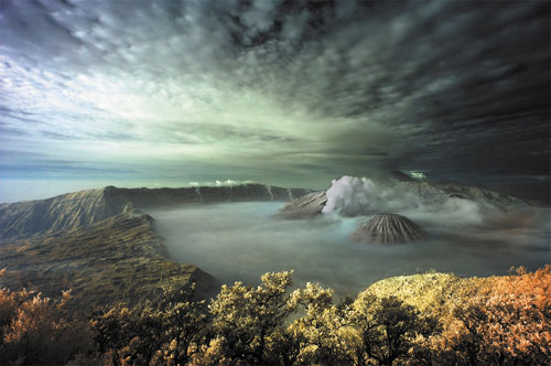
Mount Bromo
The Bromo Beauty

Bromo, Tengger, Semeru
Many local and foreign travelers make the trek for the mystical exprerience of watching the sunrise from the crest of the Bromo volcano. A pony ride from the village of Ngadisari take you over a sea of sand to the foot of the volcano. Ascend the 50 steps to reach the rim. On the vast expanse of sand , formerly a caldera , there are two volcanes; the extinct Batok which is a perfect cone and Bromo. Volcanic sulfur fumes and smoke still emanate from the depths, and when the God of Bromo begins to rumble, the surounding population quickly brings their offerings. The annual offering ceremony of Kasada is held on the 14 th day of Kasada, the twelfth month in the Tenggerese calendar year. It is a dazzling event where villagers from the surrounding areas bring their humble offerings to the holy volcano.


The East Java Tourist Information (2002)

Saturday, May 14, 2011

Cerulean Tower Hotel, Tokyo

The Cerulean Tower Hotel in Tokyo is located in the site from where the popular fashion destinations of the city are nearby. The districts like Harajuku, Shibuya and Aoyama. These places are known for the best garments and art works in Japan. While you reside at the hotel, a little stroll can make you reach thee places at ease. The name of the Cerulean Tower Hotel clearly defines the gigantic height of it, which is a 40 storey building in the heart of Tokyo. The entertainment amenities are a plenty in it as the hotel houses well-equipped theaters and jazz clubs for its guests. The best part of the hotel is the dramatic view of the city from all the rooms as all of the rooms, face the city and the enormous height gives you the panoramic view easily.

Rooms
Although the Cerulean Tower Hotel is too tall the rooms available in it are not that much plenty as you will get a total of 414 rooms in it. All the guestrooms are connected with high-speed internet access and the bedding within is nicely done with special cotton or feathers to offer the guests the pleasurable 40 winks. The basic amenities provides in the rooms are the following:
• Pay movies • Complimentary newspaper • Clock radio • Air conditioning • Iron/ironing board (on request) • Coffee/tea maker • Bathrobes • High-speed Internet access • Bathroom phone • Complimentary toiletries • Blackout drapes/curtains • Voice mail • Slippers • Daily housekeeping • Hypo-allergenic bedding available • Premium bedding • Climate control • Direct-dial phone • Internet access (surcharge) • Smoking permitted • In-room safe • Handheld showerhead • Desk • Hair dryer • Refrigerator • Cable/satellite television channels • Electronic/magnetic keys • Bidet • Wake-up calls • Minibar • Cribs (infant beds) available • Rollaway beds
Recreation
The Cerulean Tower Hotel Tokyo houses a highly decorated drama theater, night club and jazz clubs within its premises and the guests can while away their evening there easily.

Dining
The Cerulean Tower Hotel Tokyo is specialized in the dining bars and offers a variety of different restaurants and there are countless places to taste the Japanese, or any other foreign dish you prefer.
The restaurant Cou Cagno is a bar with circular counter and offers dinner and lunch as well. Bello Visto restaurant is on the 40 th floor and is decorated with wood panel and glasswork and you can dine while feel mesmerized with piano performances at the restaurant. There are total 9 different restaurants and dining bars in the Cerulean Tower Hotel Tokyo.

Friday, April 1, 2011

Luang Prabang

"The rest of the way you climb up on the left side of the waterfall, where little water is running but the stone is surprisingly not slippery at all but grips under your feet" 

Kuang Si waterfalls, nearby Luang Prabang
Luang Prabang has both natural and historical sites. Among the natural tourism sites, there are the Kuang Si Falls and Pak Ou Caves. Tourists may also ride elephants. At the end of the main street of Luang Prabang is a night market where stalls sell shirts, bracelets, tea - suitable souvenirs. The Haw Kham Royal Palace Museum and the Wat Xieng Thong temple are among the most well known historical sites. Along with the magnificent wats a significant part of the old town's appeal are the many French provincial style houses.
As China has recently allowed its citizens to travel more freely to Laos,[2] the number of tourists in the area is expected to increase rapidly, creating pressure to modernize the tourist infrastructure, particularly catering to package tourism.

Friday, March 11, 2011

Wadi Rum


img_wadirum5.jpg
Touring Wadi Rum in a hot air balloon is an unforgettable experience.
This is a stupendous, timeless place, virtually untouched by humanity and its destructive forces. Here, it is the weather and winds that have carved the imposing, towering skyscrapers, so elegantly described by T.E. Lawrence as “vast, echoing and God-like..."

img_wadirum1.jpg
A maze of monolithic rockscapes rise up from the desert floor to heights of 1,750m creating a natural challenge for serious mountaineers. Hikers can enjoy the tranquility of the boundless empty spaces and explore the canyons and water holes to discover 4000-year-old rock drawings and the many other spectacular treasures this vast wilderness holds in store.
img_moonlight.jpg
Also known as ‘The Valley of the Moon’, this is the place where Prince Faisal Bin Hussein and T.E. Lawrence based their headquarters during the Arab Revolt against the Ottomans in World War I, their exploits intrinsically woven into the history of this amazing area.
img_campsite.jpg
A campsite in Wadi Rum.
There are several options for exploring Wadi Rum. Visitors should head for the Visitors' Centre where, apart from visitors’ facilities, they can hire a 4x4 vehicle, together with driver/guide, and then drive for two or three hours into the Wadi system to explore some of the best known sites. Alternatively they can hire a camel and guide. The duration of the trip can be arranged beforehand through the Visitors' Centre, as can a stay under the stars in a Bedouin tent, where they can enjoy a traditional campfire meal accompanied by Arabic music.  
img_burdah.jpg
Burdah Rock Bridge stands 35m high and is considered one of the highest natural arches in the world.
Once transport has been arranged, there are various excursions available - for example, a trip to Burdah Rock Bridge, the highest in Wadi Rum, via the Seven Pillars of Wisdom and many other interesting sights, is a full day by car or an overnight trip by camel. There are many alternative routes and information on these is available from your tour operator or from the Visitors' Centre on-site.

The Bedouin people that inhabit the area still maintain their semi-nomadic lifestyle. They are hospitable and offer a friendly welcome to visitors, often inviting them to sit and enjoy a coffee or even a meal.
 

Tuesday, March 1, 2011

Ambon : The Original Spice Islands

the beach
The tiny islands of Ambon, Banda, Ternate and Tidore - among the thousands of islands in the Moluccas seas,- changed the course of world history from the 15th century onwards. These islands were what triggered the European Age of Exploration.

For in search of the Spice Islands in the Far East, Christopher Columbus sailed west – and discovered America. Vasco da Gama sailed south and discovered the long route around Africa’s Cape of Good Hope in 1498 to finally reach India after a long and perilous voyage. Only later did the Portuguese finally discover the sea route to Banda and Ambon. These small islands in the eastern deep seas of the Indonesian archipelago were for centuries the sole producers of the fragrant nutmeg and mace in the world. At the time these spices fetched their weight in gold in Medieval Europe.


The tiny islands of Ternate and Tidore, further north of Ambon were producers of cloves. Indian and Arab traders would sell cloves in Europe for exorbitant prices, but kept the location of their source a tightly held secret. These are the Moluccas – or Maluku – the original Spice Islands, that are now divided into the two provinces of Maluku and North Maluku.

It is from these islands that the Dutch East India Company first gained their stranglehold on the spice trade in the archipelago, gradually colonizing the Indonesian islands over three centuries, until it came to be called the Dutch East Indies, the present-day Republic of Indonesia.

As the glory days spices passed, the significance of the Moluccas waned. But it is here where the history of European explorations and colonization began.

Fortunately the beauty of that era still remains. Today, the town of Ambon is the capital of Maluku, occupying a small flat area by the beautiful Ambon Bay that is backed by lush green mountains and facing deep crystal clear waters that are alive with colorful coral gardens and untold species of marine creatures.

Although small in size, Ambon island still offers plenty of experiences for adventurous travelers. From exploring the charming Kota Ambon – the main town of the island, to walking up mountains through lush tropical vegetation, there are many undiscovered gems ready for visitors to experience.

The town of Ambon – Kota Ambon – is known as ‘Ambon Manise’ meaning sweet or beautiful Ambon. The name refers to both the beauty of the people here and the beauty of the tropical island location.

As one of the earliest places in Indonesia to be occupied by colonial powers, Ambon has a rich and ancient history. Many of the Ambonese today have mixed European and Ambonese heritage.

Visit here and discover centuries-old fortresses and the literature of local kingdoms which traces the story of the people, from periods of prosperity to escalating and controlled trades, harsh colonialism, a grueling struggle, and finally, to independence.

under water


The island also played an important role in World War II when Ambon was used as a headquarters for the Japanese military. Remnants from the war still remain, both in museums and the open air. Some war artifacts remain silently underwater. Today, these remnants are among the most valued historical sites in Ambon.

Ambon is multicultural and home to various ethnicities including the native Alifuru tribes, the migrating Javanese, Sumatrans, Minahasans, the Butons, the Arabs who came in the 9th century, the Europeans, and the Chinese who first came in the 7th century to share in the commerce of this prosperous spice island. Between 1999-2002 the island was the scene of Christian-Muslim violence however since 2004 the island has maintained a period of ongoing peace.

Saturday, February 26, 2011

Arborek Tourism Village, Raja Ampat

The village of Arborek is fast rising as a pioneer among the 18 beautiful villages in West Papua that have embarked on developing local regulations for community-based marine conservation, For this, the village of Arborek has gained an outstanding reputation among both the local authority and international community. With the assistance of the national and local government, from research centers, and non-government organizations, the local people have succeeded in formulating local regulations, naming their conservation region the Mambarayup and Indip.


Finding underwater beauty is not so difficult here. Along the Arborek pier, divers can simply plunge into the water and instantly find a most intriguing illumination of the glittering of a gorgonian fan just below the surface. People in Arborek are hospitable and very industrious, creating exceptional handicrafts from sea pandan leaves to make the most of their time each day. Arborek is fascinating both underwater and in the village.


Known as the Arborek Tourism Village, the community is known for its handicraft in making hats and noken (string bags). Unlike most women in other villages who also give a hand to their husbands as fishermen, nearly all mothers in this village produce handicrafts for a living. Although they are convinced that catching lobsters and work in pearl agro-production are much more profitable, yet they feel that handicraft is more distinguished and more graceful work for women.              T
his is a village worth visiting. Only one and half hours from

Waisai, Raja Ampat’s capital, the village of Arborek is awaiting visitors from around the world.

Monday, February 14, 2011

Baliem Valley


High up in the mountains of central Papua at an altitude of 1,600 meters above sea level, hemmed in by steep green mountain walls, lies the stunningly beautiful Baliem valley, home of the Dani tribe.
Baliem valley is 72 km. long, and 15 km to 31 km wide in places. It is cut by the Baliem river, which has its source in the northern Trikora mountain, cascading into the Grand Valley, to meander down and further rushing south dropping 1,500 meters to become a large muddy river that slowly empties into the Arafura Sea.
The first outsider to discover the valley was American Richard Archbold, who, on 23 June 1938 from his seaplane, suddenly sighted this awesome valley dotted with neat terraced green fields of sweet potatoes, set among craggy mountain peaks. This is Indonesia’s own Shangri-La.


Only recently emerged from the Stone Age, the Dani are known as the “gentle warriors”. With their simple tools of stone and bone, they nonetheless, managed to sculpt green fields that hug the hills, where they grow root crops, and raise pigs. They have also built outposts and lookout towers to defend their valley from hostile tribes.
Because of the fertile soil and their agricultural skills, the Dani together with the sub-tribes of the Yali and the Lani, are, therefore, the most populous in Papua, living scattered in small communities near their gardens among the steep mountain slopes. Today, they also cultivate bananas, taro and yams, ginger, tobacco and cucumbers.
The men's and women's huts (locally called the honai) have thick

thatched roofs, which keep the huts cool during the day and warm during the cold nights.

Sunday, February 13, 2011

Sand Lake Recreation Area dropping holiday permits

Recreation permits are being dropped for holiday weekends at Sand Lake Recreation Area south of Tillamook on the Oregon coast.

"We are discontinuing the recreation-permit system for Memorial Day, Fourth of July, and Labor Day holiday weekends," said Terry Klingenberg, a recreation technician for the Hebo Ranger District on the Siuslaw National Forest. "This also means that the users will not be charged the $10 permit processing and administration fee as they have in the past for those weekends."

While the permits are not required for holiday weekends, fees for campground sites and and for the Northwest Forest Pass apply year-round.


"We've noticed that the overall use on holiday weekends is down, so the need to regulate with a permit system is no longer necessary," Klingenberg said in a press release announcing the dropping of the mandatory permits.

For more information, go to www.fs.fed.us/r6/siuslaw.
Celebrate fossils, beach finds at festival today in Newport

This year's Fossil Fest is 10 a.m. to 4 p.m. today in Newport.

Bring your fossils or other beach finds to the Hatfield Marine Science Center for identification by Dr. William Orr, a paleontologist and co-author of "Oregon Fossils."

The Science Center is about a quarter-mile past the entrance to the Oregon Coast Aquarium in South Beach on the south side of the Yaquina Bay Bridge.

Orr also will give a presentation at 1:30 p.m. titled "Digging up the Kings Valley Groundsloth."

Other Fossil Fest activities include a fossil swap and special displays staffed by the North American Research Group.

Admission is by suggested donation.

Monday, February 7, 2011

The Maldive Islands


The Maldives was largely terra incognita for tourists until the early 1970s. Strewn across the equator in the Indian Ocean, the Maldives archipelago possesses a truly unique geography as a small island country. Nature has fragmented the archipelago into 1,190 tiny islands that occupy a mere one per cent of its 90,000 km2 territory. Only 185 islands are home to its 300,000 population, while the other islands are used entirely for economic purposes of which tourism and agriculture are the most dominant.
Tourism accounts for 28% of GDP and more than 60% of the Maldives' foreign exchange receipts. Over 90% of government tax revenue comes from import duties and tourism-related taxes.[citation needed] The development of tourism has fostered the overall growth of the country's economy. It has created direct and indirect employment and income generation opportunities in other related industries. The first tourist resorts were opened in 1972 with Bandos island resort and Kurumba Village.


According to the Ministry of Tourism website, the emergence of tourism in 1972 transformed the economy of the Maldives, moving rapidly from the dependence on the fisheries sector to the tourism sector. In just three and a half decades, the industry has become the main source of income and livelihood of the people of the Maldives. Tourism is also the country's biggest foreign currency earner and the single largest contributor to the GDP. Today, there are 89 resorts in the Maldives with a bed capacity of over 17,000, providing facilities for tourists whose annual arrival figure exceeds 600,000.[44]


The number of resorts has increased from 2 to 92 between 1972 and 2007. As of 2007, over 8,380,000 tourists had visited Maldives.[45]

Practically all visitors arrive at Malé International Airport, located on Hulhulé Island, which is next to the capital Malé. The airport is served by a wide array of flights to India, Sri Lanka, Doha, Dubai and major airports in South-East Asia, as well as an increasing number of charters from Europe. Many flights stop in Colombo (Sri Lanka) on the way.


Gan Airport, on the southern atoll of Addu, also serves an international flight to Milan several times a week.

Great Wall, China


Known to the Chinese as the 'Long Wall of Ten Thousand Li', the formidable defensive structures built to ward off invasion of the Celestial Empire by barbarians is called the Great Wall or the Wall of China by Europeans. The principle of these extraordinary fortifications goes back to the Chunqiu period (722-481 BC) and to the Warring States period (453-221 BC).


The construction of certain walls can be explained by feudal conflicts, such as that built by the Wei in 408 BC to defend their kingdom against the Qin. Its vestiges, conserved in the centre of China, antedate by many years the walls built by the Kingdoms of Qin, Zhao and Yan against the northern barbarians around 300 BC. Beginning in 220 BC, Qin Shi Huang, the founder of the Empire of the Ten Thousand Generations, undertook to restore and link up the separate sections of the Great Wall which had been built in the 3rd century BC, or perhaps even earlier, and which stretched from the region of the Ordos to Manchuria.


Towards the west, he had extended the fortifications, the first cohesive defence system of which significant vestiges still remain in the valley of the Huanghe all the way to Lanzhou shortly before the accession of the Han dynasty (206 BC). During their reign the Great Wall was extended even further, and under the emperor Wudi (140-87 BC) it spanned approximately 6,000 km between Dunhuang in the west and the Bohai Sea in the east. The danger of incursion along the northern Chinese border by the federated Mongols, Turks and Tunguz of the Empire of the Xiongnu, the first empire of the steppes, made a defence policy more necessary than ever. After the downfall of the Han dynasty (AD 220), the Great Wall entered its medieval phase. Construction and maintenance works were halted; China at that time enjoyed such great military power that the need for a defence policy was no longer felt.

It was the Ming Emperors (1368-1644) who, after the long period of conflict that ended with the expulsion of the Mongols, revived the tradition begun by Qin Shi Huang. During the Ming dynasty, 5,650 km of wall were built. To defend the northern frontier, the Wall was divided into nine Zhen, military districts rather than garrisons. At strategic points, fortresses were built to defend the towns, passes, or fords. The passageways running along the top of the wall made it possible to move troops rapidly and for imperial couriers to travel. Two symbolic monuments still proudly stand at either end of the wall - the First Door under Heaven at Shanhaiguan, located at the wall's eastern end, and the Last Door under Heaven at Jiayuguan, which, as part of the fortress entirely restored after 1949, marks its north-western end.


This complex and diachronic cultural property is an outstanding and unique example of a military architectural ensemble which served a single strategic purpose for 2,000 years, but whose construction history illustrates successive advances in defence techniques and adaptation to changing political contexts. The purpose of The Great Wall was to protect China from outside aggression, but also to preserve its culture from the customs of foreign barbarians. Because its construction implied suffering, it is one of the essential references in Chinese literature.

The Great Wall of the Ming is, not only because of the ambitious character of the undertaking but also the perfection of its construction, a masterpiece. The wall constitutes, on the vast scale of a continent, a perfect example of architecture integrated into the landscape. During the Chunqiu period, the Chinese imposed their models of construction and organization of space in building the defence works along the northern frontier. The spread of Sinicism was accentuated by the population transfers necessitated by the Great Wall.


That the great walls bear exceptional testimony to the civilizations of ancient China is illustrated as much by the tamped-earth sections of fortifications dating from the Western Han that are conserved in Gansu Province as by the admirable and universally acclaimed masonry of the Ming period.