Showing posts with label java. Show all posts

Tuesday, March 11, 2014

Ijen Crater


Ijen plateau or known as "Kawah Ijen" is highly recommended to mountain buffs and hikers. The Plateau was at one time a huge active crater, 134 sq km in area. Today, Ijen is a quiet but active volcano, and the landscape is dominated by the volcanic cones of Ijen (2,368 asl) and Merapi (2,800 asl) on the northeastern edge of the Plateau, and Raung (3,332 asl) on the southwest corner.

The magnificent turquoise sulfur lake of Kawah Ijen lies at 2148 m above sea level and is surrounded by the volcanos sheer crater walls. The vent is a source of sulfur and collectors work here, making the trek up to the crater and down to the lake every day. Sulfur collectors hike up in the morning and return around 1 pm when the clouds roll in. They carry shoulder basket of pure sulfur from a quarry on the lakes edge under the shadow of the sheer walls of the crater. The mineral at Kawah Ijen is purer and is worth commercial exploitation despite the horrendous labor involved: Javas homegrown sulfur is a natural source of sulfuric acid, in great demand in the oil-refining business and in the production of fertilizers

Source : http://www.indonesia.travel/en/destination/293/ijen-crater  ( click to see more informations)

Monday, March 10, 2014

Sempu Island


Leave all the conveniences of the modern world behind, cross the strait between concrete structures and extraordinary woods, venture into a world of natural splendor, and gaze upon some of the most mystifying sceneries on the face of the earth :  those are what  the secluded Sempu Island has to offer.
Situated on the south coast of Malang Regency in East Java and administratively located in the Tambak Rejo Village, Sumbermanjing Wetan Sub-District, this small island lies just off the coast of Sendang Biru Beach, approximately 80 Km from Malang city or about 180 Km from the capital of East Java, Surabaya. The 877 hectares forested island is a Nature Reserve under the management of the Natural Resources Conservation Office of East Java (BBKSDA) and the Ministry of Forestry of Indonesia, and was actually designated a Nature Reserve since 1928 in the Dutch Colonial period.
Among the island’s most fascinating features is the Segara Anakan lagoon located about 2.5Km further south into the island. Hidden deep beyond the thick tropical forest, the approximately 4 hectares lagoon is truly a secluded paradise where a white sandy beach meets calm blue waters separated from the raging tides of the open ocean by a picturesque rocky wall surrounding the area. The incoming tides penetrate only through several caves above and below the surface, thus the water inside the lagoon remains calm, and makes a perfect place for swimming. Its secluded location also radiates a sense of intimacy, where the beach becomes a private getaway, not unlike the setting for the 2000 Leonardo Di Caprio’s Movie “The Beach”.
Adventure awaits  those who wish to explore Sempu Island and reach the Segara Anakan Lagoon. Cross the straits from Sendang Biru Beach on the mainland to the Teluk Semut (Ant Bay) at Sempu Island. From here, the journey continues over a trekking path for about two hours through quite thick forest with several ascending and descending tracks,  before one reaches the secluded lagoon. While the trip may not be an easy walk, the grand price that awaits at the finish line is more than just worth it. Boats and guide services are available at the Sendang Biru Beach area.
Sempu Island also has other fascinating spots which offer equal splendors including the Waru-waru beach, Telaga Lele (Catfish Lake, a fresh water lake named after the many catfish found within), Tiger Cave,  Pasir Panjang Beach (Long sand Beach), Pasir Kembar Beach (Twin sands beach), Fresh Water Beach (named after a fresh water spring on the rocks near the beach), and Telaga Sat (Dry Lake).
As a Nature Reserve, Sempu Island has various types of ecosystems  ranging from coastal forest, mangroves, and lowland tropical forest which dominates the whole island. Among the vegetation found on Sempu Island are bendo (Artocarpus elasticus), triwulan (Terminalia), wadang (Pterocarpus javanicus), ketapang (Terminalia catappa), waru laut (Hibiscus tiliaceus), pandan (Pandanus tectorius), Mangroves (Rhizophora mucronata and Rhizophora apiculata), and many more. Interestingly, the name Sempu is said to have been taken from a particular type of tree that is found in the island, however, the tree can hardly be found these days.
The Nature Reserve is also home to several wildlife inhabitants such as:  the Javanese Monkey (Tracypithecus auratus), Black Monkeys (Presbitis cristata pyrrha) , Grey Macaques  (Macaca fascicularis), wild boar (Sus sp), deer (Muntiacus muntjak), kancil/small deer (Tragulus javanicus), Prawn (Alcedo athis), belodok fish (Periopthalmus sp), crab (Ocypoda stimsoni), and many more. There are also several types of reptiles including giant lizards and snakes and also several types of birds that find shelter on the island.

Monday, February 11, 2013

Pantai Kondang Iwak

 Lokasi Pantai Kondang Iwak tersembunyi di deretan pesisir selatan Malang. Meski telah tersedia akses berupa macadam yang cukup rata, tapi jarang wisatawan yang mengunjungi pantai yang memiliki hamparan pasir lembut yang luas ini. Pantai ini berada di sekitar  Desa Tulungrejo, Kecamatan Donomulyo, Kabupaten Malang.  Sebagai tambahan, di depan pantai ini terdapat laguna yang memanjang sekaligus sebagai muara di ujungnya apabila air pasang, membentuk seperti danau apabila surut, dengan kanan-kiri tebing karang sepanjang danau.Kondang Iwak ini juga bisa berarti banyak ikan menurut warga sekitar.

Pantai ini memiliki panorama pemandangan hamparan pantai luas dengan perpaduan pasir putih dan pasir besi. Pengunjung juga disuguhkan dua buah pulau bernama Pulau Lawang yang berarti pulau pintu.
Jika puas bermain di tepi pantai, pengunjung bisa berjalan menyusuri pantai ke arah barat menuju muara sungai air payau Kondang Iwak. Biasanya pada akhir pekan banyak wisatawan sengaja memancing hingga bermalam dengan mendirikan tenda.

Wednesday, January 9, 2013

Keripik Buah - Oleh oleh Khas Malang

Kripik Nangka
Jalan jalan ke Kota Malang belum terasa lengkap jika belum mencoba keripik buah. Keripik buah terbuat  ari buah buahan segar yg di olah sedemikian rupa. Ada banyak macam buah yang bisa di buat keripik ,  ntara lain apel, nangka, nanas , rambutan, salak, mangga, bahkan saya pernah liat ada keripik semangka. What???.

Saya pernah coba menggoreng nangka secara langsung seperti menggoreng tempe, hasilnya nangka tidak menjadi kering dan renyah seperti yang saya harapkan , nagkanya malah menjadi lembek. Semakin lama di goreng juga tidak bisa semakin kering tapi malah gosong.
Setelah dikemas

Hahahahaha... Penasaran cara buatnya jadi saya coba mencari cara membuatnya. Akhirnya ketemu juga jawabannya. 
Membuat keripik nangka membutuh kan alat menggoreng khusus yang disebut vacuum frying. 
Apa itu vacum frying? Vacuum frying  adalah mesin produksi untuk menggoreng berbagai macam buah dan sayuran dengan cara penggorengan hampa. 
Penampakan 
Prinsip kerja alat ini adalah menghisap kadar air dalam sayuran dan buah dengan kecepatan tinggi agar pori-pori daging buah-sayur tiak cepat menutup, sehingga kadar air dalam buah dapat diserap dengan sempurna. Prinsip kerja dengan mengatur keseimbangan suhu dan tekanan vakum. Untuk menghasilkan produk dengan kualitas yang bagus dalam artian warna, aroma, dan ras buah-sayur tidak berubah dan renyah pengaturan suhu tidak boleh melebih 85° C dan tekanan vakum antara 65 ± 76 cmHg. Waduh saya males jelasin lebih lanjut prinsip kerja alat ini. oka itulah intinya. * Cari di google aja yang lebih lengkap. hahaha Siapakah orang yang menciptakan alat ini??? 
Adalah Ir Anang Lastriyanto MSi yang berhasil menciptakan mesin vacuum frying.Beliau adalah dosen Fakultas Teknologi Pangan 
penampakan
(FTP) Univerrsitas Brawijaya Malang.


Thursday, June 23, 2011

Balekambang Beach

balekambang beach
The beach possessing three islands with distance of about one hundred meters each, two of which have been connected with one meter-wide bridge to the shore, Balekambang offers a different atmosphere of beach resorts in the Southern part of Malang. One of the three islands called Ismoyo island has a Hindu temple, established by local Hinduists.
Annually, the ritual and traditional ceremonies Jalanidhipuja (Hindu ceremony) and Suran (Javanese New Year ceremony) are held here every year. The parking area, stalls, inns, souvenir shops, and the others tourism facilities has provided for the visitors. This beautiful beach is located at Srigonco village, Bantur district, about 57 km away to the south from Malang and accessible by public transportation.
Visit Balekambang Beach tourism and enjoy its wonderfull waves with softe sea wind. Watch the sunset and sunrise in this beach and do some of beach activities, such as; swimming, sun bathing, fishing, etc.
balekambang sunset

beautiful beach

Saturday, May 21, 2011

Places of Interest In East Java

Surabaya
A booming city over 3 million people , Surabaya offers many good hotels, shopping centers and plentiful sources of entertainment. Its wellstocked zoological garden includes several species of Indonesian fauna : orang utans, komodo, dragons and a collection of nocturnal animals. Kalimas is an old traditional harbor for tha world famous Bugis schooners , which can be still be seen in all their former glory. Across the Madura Strait , half an hour by ferry from Surabaya is the island of Madura , famous for its unique bull races.


Trowulan, Pandaan, Tretes
Trowulan village and the surrounding area are believed to be the site of the ancient capital of Majapahit. Archaeological excavations in the area have recovered many terracotta ornaments , statues, pottery, and stone carvings which are displayed at the Trowulan museum. The map in the museum is a guide to nearby sites of historical interest. The Chandra Wilwatika open air theatre in Pandaan, 45 km south of Surabaya Presents classical East Java ballet performace on each full moon night from June to November. The performances are based either on the Ramayana stories or East Java’s legends and folklore. The backdrop of Mt. Pananggungan makes the performances and enchanting experience. 10 km from Chandra Wilwatikta is Tretes, one of the most beutiful mountain resort of East Java.

Malang


Ninety kilometers south Surabaya lays Malang, one of the most attractive hill towns on Java. A strong sense of civic pride is evident from the well maintened and elaborately painted pedicabs, the groomed main square , and clean buildings streets. The cool climate is a welcome flank of Mt. Arjuna , are Selecta and Songgoriti, popular hill resort with hot springs. Nearby Batu is famous for its apples and flowers. Sport facilities at Selecta include horse riding, swimming, and tennis.
Tugu kota Malang
Balai kota

Mount Bromo
The Bromo Beauty

Bromo, Tengger, Semeru
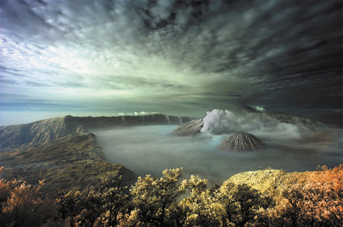
Many local and foreign travelers make the trek for the mystical exprerience of watching the sunrise from the crest of the Bromo volcano. A pony ride from the village of Ngadisari take you over a sea of sand to the foot of the volcano. Ascend the 50 steps to reach the rim. On the vast expanse of sand , formerly a caldera , there are two volcanes; the extinct Batok which is a perfect cone and Bromo. Volcanic sulfur fumes and smoke still emanate from the depths, and when the God of Bromo begins to rumble, the surounding population quickly brings their offerings. The annual offering ceremony of Kasada is held on the 14 th day of Kasada, the twelfth month in the Tenggerese calendar year. It is a dazzling event where villagers from the surrounding areas bring their humble offerings to the holy volcano.


The East Java Tourist Information (2002)

Monday, February 28, 2011

World's Best Surfing at G-Land


Indonesia is a country with some of the worlds best surf spots and there are none that are better than Plengkung beach at Grajagan, East Java. Nicknamed by surfers as the ‘gland’ or G-land  – the surf here consistently produces some of the best and most well known waves in the world.

Set amongst picturesque jungle surrounds, prepare for an exhilirating experience surfing world class waves. The beach is located on the edge of a national park rich in exotic flora and fauna – the ideal scenic background to your surfing odyssey.

The internationally renowned waves at this beach are famous for their extremely long length of tube time. The long perfect barrels are the stuff surfers dreams are made of. The beach is divided into three sections, Kongs, Money Tree and Speedies. Money Tree is Grajagan’s premier wave.

Despite it’s popularity in the surfing community, accomodation around Grajagan remains good value with cheap losmen and basic cottages dotted about the place.


This is one of the only places in all of Java that has such excellent surfing. In season, Grajagan probably has the most consistently rideable waves in the world. The surf here though is demanding and only recommended for professional surfers.
For more details on Grajagan Surfing, visit: www.grajagan.com.au

Friday, February 25, 2011

Crater at Mount Tangkuban Perahu


Mount Tangkuban Perahu, or also commonly referred Tangkuban Parahu is one of the largest mountain plateau Parahyangan. Nature Park Mount Tangkuban Perahu in the northern city of Lembang, north of the city of Bandung. Cool weather, the spread of tea gardens, valleys and tall pine trees to accompany your journey toward the gate area Tangkuban Perahu.

Tangkuban Perahu have two road craters that exist on this mountain. The first street or road longer by road conditions more difficult to pass and will normally be closed after the rain or when deemed dangerous to pass. The guard booth will give clues to past the new road which lies further to the top if the road was closed. Before the ticket payment in the first street, there are cottages for rent for a place to stay.

Passing through the new road, paved roads facilitate travel of your vehicle. On the street side there is winding trumpet flowers and other trees that will soothe your trip. Tangkuban Perahu mountain in the region there are three craters of interest to visit. Domas Crater is a crater, Crater Queen and Upas Crater. The largest crater between the three and most visited are Queen Crater. With a few hours walk away, you can even round the Queen is so wide crater while enjoying the beautiful panorama of Mount Tangkuban Perahu.


Queen Crater
If you come by bus, there is a special bus parking lot before reaching the crater Queen. The journey continues with ELF car that will get you into the crater of the Queen. However, if you use a private vehicle, you can continue to use it up to the crater Queen. Parking is available across the vehicle in this crater, so without going through the difficult terrain and spend a lot of energy, you can see this crater. It may also be one reason, most visitors in this crater.

Queen Crater directly visible from the top with a wooden barrier fence to prevent visitors falling. Looking inside the crater, the walls of the crater and smoke is still out of the crater it creates a thrilling sight. Soil around the crater Queen mostly white with some yellow brimstone. Rocks and the atmosphere was dry and arid in this crater. You can try to climb to higher ground if you want to see the Queen Crater region as a whole.

In this place a lot of simple shops selling various souvenirs such as scarves, skullcaps hats, bags and fur hats, various displays of wood and various other accessories. There are also sellers of food and warm drinks such as boiled noodles, and other bandrek. You can also ride horses to round some of these craters. This activity is usually favored children.

Upas Crater
Upas Crater Crater is located next to the Queen. But, to be able to see this crater must go through dangerous terrain, you must pass through the sandy road to reach the crater. So, very rare visitors who come to see this crater. The form is different from Upas Crater Crater Queen. Upas crater is more shallow and flat.

Domas Crater
Domas Crater Crater is located further down than the Queen. If you come through the new path, you'll find the gateway to Crater Domas Crater first before heading to the Queen. If the crater Queen you will only see the crater from a distance, the Domas crater, you can get closer to the crater. In fact, you can try to boil eggs by putting it in the crater. If you want to see past the Domas Crater at 16:00 pm, you are required to use the services of tour guides.

Manarasa
Trees are much visible around the crater is a tree called by local people with the name Manarasa. The leaves of this plant will be reddish in color if the leaves are old. Red leaf that had to be eaten with guava leaves taste like with a little sour taste. These leaves can treat diarrhea and is believed will make the youth. Perhaps this leaf is trusted by the local community is always eaten by Dayang Sumbi are ageless in the legend of Mount Tangkuban Perahu.


Tangkuban Legend Boats
The core story of the legend of Tangkuban Perahu is a young man named Sangkuriang want to marry a woman named Dayang Sumbi beautiful. They fell in love. However, after finding the scar on his head Sangkuriang, Dayang Sumbi Sangkuriang is that they found out his son. Sangkuriang go first because he felt annoyed with her anger. Dayang Sumbi angry because Sangkuriang killing their pet dog when it fails to hunt deer for his mother.

Knowing Sangkuriang is his son, Dayang Sumbi Sangkuriang not want to marry. So, to reject the application Sangkuriang, Dayang Sumbi asked for a boat besarta lake within 1 night. Sangkuriang who ask for help from the magic genie to fulfill the desire Dayang Sumbi.

Viewing Sangkuriang almost completed its work, Dayang Sumbi intend blew it. Thanks to his prayer, the chickens crowing. Jin-jin who helped Sangkuriang running scared because he thought it was morning. As a result of work to make the boat and the lake is not completed. Sangkuriang who was furious because it failed to complete his work kicked homemade boat. The boat is then fell face down and there was Mount Tangkuban Perahu. When viewed from the city of Bandung, the mountain resembles an inverted boat.

The beauty of the crater of Mount Tangkuban Perahu and some spots around it also became one of the places for potential brides to do outdoor wedding photos. The beauty of the craters of Mount Tangkuban Perahu can become one of the destinations if you're visiting the city of Bandung. You can bring the kids to see this natural beauty.

Prambanan : The Exotic Hindu Temple


As the largest Hindu temple in Southeast Asia, the beautiful and graceful temple of Prambanan is a magnificent spectacle and an icon of Indonesia’s cultural heritage.

Located not far from the Buddhist Borobudur temple, the proximity of the two temples tells us that on Java, Buddhism and Hinduism lived peacefully next to one another.

Prambanan is known locally as Roro Jonggrang, coming from the legend of the ‘slender virgin’. According to the legend once upon a time, there was a young and powerful man named Bandung Bondowoso. He wanted to marry a beautiful princess named Roro Jonggrang. Her father, the king, agreed and forced her to marry Bandung Bondowoso. Butm Sita did not love him yet could not refuse him.

After careful consideration, she thought of a way to refuse Bondowoso, whose magical power was well-known. She decided she would agree but only if Bondowoso built 1,000 temples in one night before the break of dawn.


She insisted that the work must be completed before the rooster crowed, something she believed was impossible. But with the help of genies and his own magical powers, Bondowoso managed to complete 999 temples. Panicked, Jonggrang told the women of her village to start pounding rice so that the rooster would wake up and begin to crow. When Bondowoso heard this he was deeply disappointed and wildly enraged. When he found out that Roro Jonggrang had made the roosters crow, he turned her into stone, The statue of a slender virgin graces the main Prambanan temple, while a group of temples nearby is called the Candi Sewu or the Thousand Temples.

The temples at Prambanan were built in the 9th century. The biggest temple is dedicated to Shiva – the destroyer, and the two smaller ones which sit on its right and left are dedicated to Brahma -¬ the creator and Wisnhu – the sustainer. The tallest temple of Prambanan is a staggering 47 meters high. Its peak visible from far away and rises high above the ruins of the other temples.


After hundreds of years of neglect, the Prambanan temple was rediscovered by CA Lons, a Dutchman, in 1733. Since then, this temple has been revitalized and today is widely regarded as the most beautiful and graceful Hindu temple in Indonesia.

The grandeur, complexity, and integrated architectural concept of Prambanan makes this a truly amazing structure. As a unique cultural and architectural marvel, Prambanan was declared a World Heritage site in 1991 by UNESCO.

Thursday, February 10, 2011

Bogor Botanical Gardens


Just 60 km south, or a mere one hour by road from Jakarta lies the town of Bogor, once known as “Buitenzorg” meaning “free of care”, located at the foothills of Mt. Salak. It has a high, year-round rainfall and a much cooler climate compared to metropolitan Jakarta. Here are spread out the 87 hectares world famous Bogor Botanical Gardens (Kebon Raya Bogor), with the impressive out-of-town Bogor Presidential Palace fronting it and soaring Mt. Salak at its background.


Bogor Botanical Gardens boasts over 400 species of palm trees, 5,000 trees gathered from around the tropical world, and an orchid house containing 3,000 varieties. Records show that the Bogor Botanical Gardens harbours 3,504 plant species, 1,273 genus in 199 families.

The Gardens are said to have been initiated by Sir Thomas Stamford Raffles, who, between 1811-1816, became Governor General of the East Indies during the interim reign of the British over the archipelago. With the help of botanists from London’s famed Kew Gardens, Raffles first laid out a small garden. However, the Gardens were officially established by the Dutch in 1817 under the directorship of CGC Reinwardt. A memorial to Raffles’ wife still stands in the Gardens.


The Bogor Gardens today function as an ex situ conservation site, a research center for taxonomy and plant utilization. In horticulture the Gardens study adaptation, planting and propagation of plants and develop the science of plant growing.

Karimunjawa Island

The Karimunjawa archipelago is situated in the Java Sea, 45 nautical miles away from Jepara Regency and 60 Nautical miles from Semarang, the capital city of Central Java Province. Karimunjawa is known for its amazing fringing coral reefs, diving sites, and sandy beaches. The reefs are a combination of fringing, barrier, and patch with bottom depths ranging from 15 to 40 meters.


Karimunjawa archipelago consists of 27 islands scattered along the Java Sea. Five of them, namely Karimunjawa, Kemujan, Parang, Nyamuk and Genting, are inhabited. The area is 111,625 acres in width, consists of 7,033 acres of land and 104,592 acres of water; Most of the islands are untouched and beautiful, where visitors can indulge in diving, fishing and sunbathing.


Some islands are formed by coral reefs and covered with a sand layer. The coast is mostly overgrown with mangrove and other marine plants. The ecosystems, consists of five types: coral reef, sea grass and seaweed, mangrove forest, coastal forest and low land tropical rain forest, offering maritime tourism object and natural adventure. Due to its unique and natural marine life, the islands are conserved and declared as a National Marine Park.


The most interesting tourism object in these islands is the marine area, there are more than 30 dive sites across Karimunjawa Marine National Park. There are shallow dive sites with weak or even without currents for beginners, as well as the deep ones with strong currents for more advanced divers suitable for all levels of divers, from beginners to experienced ones. Interested divers can also explore several shipwrecks of old merchant ships at various depths.

The most famous marine tourism area in the archipelago is Menyawakan Island; it is a good place
for snorkeling, ringed by a beautiful coral reef like the other islands in Karimun Jawa. The water around this resort island is so clean and the reef is clearly visible from the surface. Visitors may find an awesome experience snorkeling around the island floating and following the current around to see abundant of colorful coral reef, coral fishes and other underwater species live here. The shallow and clear water around the islands allows visitors to watch under water living from the surface using glass bottomed boat. Or visitors may just spend the time by doing other water-sports such as fishing, sailing, windsurfing, water-skiing, and jet skiing around the island.


Another interesting activity here is feed and play with white tip shark at the conservation pond in Menjangan Kecil Island, there is a shark breeding site where 0.5 to 2 meters young sharks swim around freely. Another breeding site is in the Floating Cottage; a wooden Cottage that floats on a breeding area of white sharks. While on the white sandy beaches of Menjangan Besar Island and Cemara Kecil visitors can find perfect locations forsunbathing.


Best Time to Visit
The best time to visit the islands is from April through November. It can also be visited from December through March, but due to the rainy season, visitors may experience stronger winds and bigger waves. The most comfortable time to visit the Karimunjawa is from April to July and September to November because of the calm water and wind.


How to Get There
From Jakarta, Karimunjawa can be reached by domestic flights served by Garuda Airways, Mandala Airlines, Lion Air, Sriwijaya Air and Batavia Air to Semarang. And then from Semarang there are two options to reach Karimunjawa; using plane or speed boat. Visitors may use chartered flight from Ahmad Yani Airport or KMC KARTINI I speed boat from Tanjung Mas Harbor. Approximately it needs 3 hours sailing from Semarang to Karimunjawa by boat.
Beside the two options above there is public ferry KMP Muria departs from Kartini Harbor Jepara. It needs 5 - 6 hours to reach Karimunjawa from Jepara by KMP Muria, while transportation between the islands is served by local fishermen’s boats, which can be hired anytime.

Wednesday, January 26, 2011

Mount Bromo, East Java

mt. Bromo

In a country full of natural beauty, one of the most spectacular sights is Tengger Caldera. The collapsed remnants of an ancient volcano forms a steeply walled crater nearly 10 kilometers (six miles) in diameter. Rising from the nearly flat volcanic sand floor of the caldera is the dormant cone of Mount Betok and the active volcano of Mount Bromo. Just south of the caldera walls is Mount Semeru, Java's highest mountain and most active volcano. All of this has been incorporated as the Bromo-Tengger-Semeru National Park.

The mountain complex is about 120 kilometers (80 miles) south of Surabaya and can be visited as a day trip, sort of. As with many such sights, "the thing" to do is see the sunrise over the caldera. This means getting to the lookout point on Mount Penankajan, the highest point on the north rim of the caldera, by about 4:30 in the morning. If you decide take this route, keep in mind that it can be quite cold in the pre-dawn mountains. On my visit, the air temperature was probably not more than 5°C and there was a high wind making it feel well below zero. There are many people on the approach to the lookout willing to rent you parkas if you don't want to haul your ski jacket around tropical Indonesia.

As you're waiting for the sun to make an appearance, don't forget to look up. High up on a mountain and far away from the lights of any big city, you'll see a sky filled with stars, that sadly few people get to see these days. As the eastern horizon begins to redden, you'll be able to make out the shapes in the caldera below you. Bring a camera tripod if you want to get good photos in the still-dim light. Once the sun actually appears over the horizon, to be greeted by yells from the assembled crowd, it's then time to make your way to the crater floor.
The steep road down to the floor of the caldera comes out opposite to Mount Betok, with Mount Bromo behind. The floor of the caldera is find volcanic sand, which is often called the Sand Sea or Lautan Pasir. Crossing the Sand Sea is usually done by jeep. On rounding the base of Mount Betok, you're greeted by two rather incongruous sights. One is a Hindu Temple, and the other is cowboys. The temple is a reminder that some of the Hindu Tengger people stayed behind when the Majapahit empire fell and many others fled to Bali. The cowboys are there to sell you their services, or rather, the services of their horses.
Add caption


Just beyond the Hindu temple are the lower slopes of Mount Bromo. The jeeps only go as far as this, and the choice is to either walk across the slick volcanic sands to the base of Bromo's cone, or ride one of the horses on offer. Most people goes on the ponies, probably because it's included in the price of the tour. The horses will take you only to the base of the steep sides of the cone. From there you have to climb a rather steep stairway.

The stairs end at the rim of the crater, from where you can look down into the volcanic vent at the bottom. The vent is not much more than a big crack in the ground spewing steam. You can see bright yellow deposits of sulphur on the walls of the vent. Of course, you also have a view back across the Sand Sea to the lookout on Mount Penankajan where you watched the sun rise.

See our three-dimensional satellite map of the Tengger Caldera area for an overview of the places discussed in this article. If you'd like to see more photos of Mount Bromo, please see the online photo gallery at our Chieng Fa travel journal.

Getting to Mount Bromo

Most hotels in Surabaya can arrange a tour to Mount Bromo. These will generally leave Surabaya around midnight in order to make it to the Mount Penankajan viewpoint in time to watch the sun rise. Alternatively, you can choose to stay at one of the small hotels and guest houses that have sprung


up on the mountain. The top end of these is Bromo Cottages in Tosari. The rooms and facilities are rather basic, but comfortable enough for the half night or so that you'll spend there. Your wake-up call from the front desk will come around 3:30 a.m. for the 45 minute trip up to the lookout. Bromo Cottages can arrange for transport to and from Surabaya (by private car, pay around 400,000 Rupiah / 44.00 USD) as well as a jeep to take you up and into the caldera. If you choose to stay up on the mountain, you can leave Surabaya around 15:00 to make it to your lodging around sunset, then get a few hours sleep right after dinner.

Borobudur Temple


Borobudur, or Barabudur, is a 9th-century Mahayana Buddhist monument near Magelang, Central Java, Indonesia. The monument comprises six square platforms topped by three circular platforms, and is decorated with 2,672 relief panels and 504 Buddha statues.[1] A main dome, located at the center of the top platform, is surrounded by 72 Buddha statues seated inside perforated stupa.

The monument is both a shrine to the Lord Buddha and a place for Buddhist pilgrimage. The journey for pilgrims begins at the base of the monument and follows a path circumambulating the monument while ascending to the top through the three levels of Buddhist cosmology, namely Kāmadhātu (the world of desire), Rupadhatu (the world of forms) and Arupadhatu (the world of formlessness). During the journey the monument guides the pilgrims through a system of stairways and corridors with 1,460 narrative relief panels on the wall and the balustrades.

Evidence suggests Borobudur was abandoned following the 14th-century decline of Buddhist and Hindu kingdoms in Java, and the Javanese conversion to Islam.[2] Worldwide knowledge of its existence was sparked in 1814 by Sir Thomas Stamford Raffles, then the British ruler of Java, who was advised of its location by native Indonesians. Borobudur has since been preserved through several restorations. The largest restoration project was undertaken between 1975 and 1982 by the Indonesian government and UNESCO, following which the monument was listed as a UNESCO World Heritage Site.[3] Borobudur is still used for pilgrimage; once a year Buddhists in Indonesia celebrate Vesak at the monument, and Borobudur is Indonesia's single most visited tourist attraction

LOCATION

Approximately 40 kilometers (25 mi) northwest of Yogyakarta, Borobudur is located in an elevated area between two twin volcanoes, Sundoro-Sumbing and Merbabu-Merapi, and two rivers, the Progo and the Elo. According to local myth, the area known as Kedu Plain is a Javanese 'sacred' place and has been dubbed 'the garden of Java' due to its high agricultural fertility.[13] Besides Borobudur, there are other Buddhist and Hindu temples in the area, including the Prambanan temples compound. During the restoration in the early 1900s, it was discovered that three Buddhist temples in the region, Borobudur, Pawon and Mendut, are lined in one straight line position.[14] It might be accidental, but the temples' alignment is in conjunction with a


native folk tale that a long time ago, there was a brick-paved road from Borobudur to Mendut with walls on both sides. The three temples (Borobudur–Pawon–Mendut) have similar architecture and ornamentation derived from the same time period, which suggests that ritual relationship between the three temples, in order to have formed a sacred unity, must have existed, although exact ritual process is yet unknown.[9]

Unlike other temples, which were built on a flat surface, Borobudur was built on a bedrock hill, 265 m (869 ft) above sea level and 15 m (49 ft) above the floor of the dried-out paleolake.[15] The lake's existence was the subject of intense discussion among archaeologists in the 20th century; Borobudur was thought to have been built on a lake shore or even floated on a lake. In 1931, a Dutch artist and a scholar of Hindu and Buddhist architecture, W.O.J. Nieuwenkamp, developed a theory that Kedu Plain was once a lake and Borobudur initially represented a lotus flower floating on the lake.[10] Lotus flowers are found in almost every Buddhist work of art, often serving as a throne for buddhas and base for stupas. The architecture of Borobudur itself suggests a lotus depiction, in which Buddha postures in Borobudur symbolize the Lotus Sutra, mostly found in many Mahayana Buddhism (a school of Buddhism widely spread in the east Asia region) texts. Three circular platforms on the top are also thought to represent a lotus leaf.[15] Nieuwenkamp's theory, however, was contested by many archaeologists because the natural environment surrounding the monument is a dry land.

Geologists, on the other hand, support Nieuwenkamp's view, pointing out clay sediments found near the site.[16] A study of stratigraphy, sediment and pollen samples conducted in 2000 supports the existence of a paleolake environment near Borobudur,[15] which tends to confirm Nieuwenkamp's theory. The lake area fluctuated with time and the study also proves that Borobudur was near the lake shore c. 13th and 14th centuries. River flows and volcanic activities shape the surrounding landscape, including the lake. One of the most active volcanoes in Indonesia, Mount Merapi, is in the direct vicinity of Borobudur and has been very active since the Pleistocene